
Welcome to the NH Zoning Atlas
New Hampshire's zoning, community-by-community, district by district
Includes zoning changes adopted through June 1, 2024
The New Hampshire Zoning Atlas is a comprehensive database and interactive online map cataloging and portraying district-level land-use regulations affecting housing construction across the entire land area of the state.
The Zoning Atlas is policy-neutral, but the maps and data linked below suggest that there is much that New Hampshire can do to adjust our zoning to help our communities to flourish, and to assist our state in attracting and retaining young people, growing families, aging seniors, and a workforce for our economy.
Click the various links below to use the atlas, download the data, read about our methodology, review our findings, and more.
The NH Zoning Atlas is the product of a statewide effort, including a dedicated team of student researchers, data analysts, zoning experts, and experienced GIS (geographic informations systems) professionals, as well as community funding and advice and guidance from the National Zoning Atlas project.

Click below to see our statewide findings with accompanying images and additional data.

Click below to see our statewide findings with accompanying images and additional data.

Click below to see our statewide findings with accompanying images and additional data.

Click below to see our statewide findings with accompanying images and additional data.
Click below to see our statewide findings with accompanying images and additional data.

Visual Summary of the Atlas
Our visual summary of the atlas gives a detailed explanation of methodology and findings including a Manchester-area analysis. Click the button below for our introduction, methodology, and major findings.
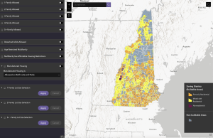
Interactive Zoning Atlas
The interactive zoning atlas has the ability to search by location and call up details related to family treatment, ADUs, affordable housing, elderly housing, setback requirements, lot coverage restrictions, parking restrictions, etc. for every zoning district in the state.
Our Downloadable Assets
To access the data and analysis that informed our methodology, click the button below. Please contact us should you have any corrections that we should be made aware of.
Corrections? We froze the zoning data on June 1, 2024, and subsequently collected nearly 400,000 pieces of data from reading over 23,000 pages of NH community zoning codes.
If you see a correction, please help us by emailing us the details at zoningatlas@anselm.edu.
Meet the students who did the hard work of collecting data for the Atlas!

Our Leadership Team

Max Latona
Executive Director,
Office of Partnerships, Saint Anselm College

SARAH WRIGHTSMAN
Manager, Community Engagement and Education,
NH Housing

Noah Hodgetts
Principal Planner,
NH Office of Planning & Development

Rick Lederer-Barnes
GIS Specialist & Environmental Planner,
Upstate GIS

Sarah Marchant
Chief of Staff and Vice-President of ROC-NH,
Community Loan Fund

JASON SORENS
Senior Research Faculty,
American Institute for Economic Research

Emily Hamilton
Senior Research Fellow,
Director of Urbanity Project, Mercatus Center

NICK TAYLOR
Executive Director,
Housing Action NH

ALEXSANDRA GALANIS
Manager, Research and Data Analytics,
NH Housing

JENNIFER CZYSZ
Executive Director,
Strafford Regional Planning Commission

ELISSA MARGOLIN
Director, Initiative for Housing Policy and Practice,
Saint Anselm College

Want to learn more about the Atlas?